Measure crop moisture content and soil water content
Being able to measure crop moisture content remotely, or to determine if there is any water lodging area of the field, can give you valuable insights on your crop and field performance. In this Agtech Letter we look at two indices that can be useful tools.
How can you measure moisture and water remotely?
Similarly to how it is possible to measure biomass for a crop using different vegetation indices as were described in Agtech Letter #18 and Agtech Letter #19, it is possible to use data from multispectral camera images to also compute indices that are related to properties for moisture and water.
In this Agtech Letter we will look at two different indices that are quite similar and related, but measure different properties and have different use-cases. The first index is NDMI and the other is NDWI, and it is important to be very precise in the definition of these since there are multiple definitions of NDWI where one is identical to NDMI (Gao’s definition) and the other is not (McFeeter’s definition). We will, similarly to many others, use NDMI to denote Gao’s index and NDWI to describe McFeeter’s index. The differences will be explained in this Agtech Letter and there should be no confusion about which index we mean once you have read the letter.
The similarity, and sometimes confusing use, of the NDMI and NDWI indices is a perfect example that showcase the fact that vegetation indices are not a scientific truth, but rather defined by scientists and researchers to determine different relations between parameters (some crop property and mutlispectral image data). This is, however, not a problem if we are aware of what index we use and how it is defined. The different indices are still a powerful tool to understand your crops and fields, but keep in mind that there are several indices with similar definitions.
Measure crop moisture content during the season
In 1996, Bo-cai Gao proposed an index that could be used to estimate how much moisture that a crop contains by measuring reflectance of light in the short-wave infrared (SWIR) spectra.
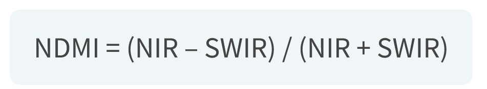
Normalized Difference Moisture Index (NDMI)
The NDMI index is based on the reflectance of light in the near infrared (NIR) spectra and the SWIR spectra. The reflectance of NIR light is not very dependent on the moisture content but more so on the dry matter of the crop. The reflectance of SWIR light, on the other hand, is clearly affected by the moisture content. If the moisture content in the crop is increased, the amount of reflected SWIR light decrease and vice versa. Hence, using NIR and SWIR light it is possible to create an index that can measure crop moisture content as
NDMI = (NIR – SWIR) / (NIR + SWIR)
By now, you probably recognize the format used by many vegetation indices, and it is true also for the NDMI index that ranges between -1 to 1. Everything below 0 is indicating a low, or no, crop moisture content and is usually considered to be soil och dried crops. NDMI values above 0.6 indicate a very high crop moisture content, and even lodging water in the case of NMDI values close to 1. In the interval between 0 to 0.6, the crop moisture content is considered to increase with an increasing NDMI value.
How to use the NDMI index, and what to keep in mind
The NDMI index can be useful to determine if the crop experiences water stress, information that for example can be used to determine the need for irrigation or other actions, or to understand how dry the crop when planning the harvest to start with the most dry crops. However, keep in mind that the NDMI index and its interpretation is dependent on the crop growth stage and the type and variety of the crop. This is more or less true for most vegetation indices, and it is a good habit to never use them without getting a ground truth by visiting the field.
Find water logging on your fields
Water logging areas on your field can be easy to detect visually, but to make it more efficient to find and store data about areas with water logging you can use the NDWI index as a tool.
Normalized Difference Water Index (NDWI)
The NDWI index is using the measured reflectance of green light and NIR light. Since a water surface reflects much of the green light but quite little of the NIR light, and a vegetation reflects much of the NIR light it is possible to create an index that can estimate what is water and what is land. This index is called NDWI and is computed as
NDWI = (GREEN – NIR)/(GREEN + NIR)
The NDWI index ranges between -1 and 1, as for the other indices we have looked at. A large reflectance of green light combined with a low reflectance of NIR light gives a NDWI value that is close to 1 and corresponds to a water surface, whereas the having reflectances the other way around gives a NDWI values close to -1 and probably corresponds to soil and vegetation. Hence, as a rule-of-thumb, negative NDWI values are related to land, and positive NDWI values are related to water. Water surfaces are often considered to have NDWI valuesof 0.5 to 1.
How to use the NDWI index, and what to keep in mind
The NDWI index can primarily be used to find water surfaces on for example fields, but some say that it can also be used to measure soil moisture content. However, this is not very well established and there are other ways that this could be done more reliably, as we will see in the next Agtech Letter. By finding the water logging areas after heavy rains and melting snow, you could analyze and find areas where the drainage system is not performing well, or to find areas of the fields that you need to check and determine whether the crops have drowned and need to be seeded again. By collecting this information over several years, you could start to see trends in if and where the water is logging in the fields, which could be used to plan future drainage improvements.
A conclusion on vegetation indices
In the last couple of Agtech Letters, we have looked at a few commonly used vegetation indices, but it is far from all indices that are available. Other interesting indices are Lead Area Index (LAI) that measure the area of leafs available for photosynthesis, and Red Edge Chlorophyll Index (RCI) that can be used for measuring the chlorophyll content in the crop. A comprehensive list of all vegetation indices can be found at the Index DataBase. Besides the classical vegetation indices, a more powerful analysis of multispectral images can be done using methods from machine learning, which is a topic we will revisit in a future Agtech Letter or Agtech Deep Dive.
Here, at the end of this series on vegetation indices, we can conclude with a few things to keep in mind when using vegetation indices from satellite and drone images.
Vegetation indices are an approximation
The indices that are computed from data does not measure the exact same thing that you want to know more about, but they are rather an approximation of the real world based on a few spectral bands.
Vegetation indices can vary with time
The vegetation indices are often developed and tuned to work best at certain crop development stages and or parts of the season, and it’s a good habit to understand when and how you can use the vegetation index at hand.
Vegetation indices gives you a quick overview but you need to visit the field
A vegetation index can indicate that a crop is thinner, more stressed, or is missing something at parts of the field, but it can’t fully understand the underlying problem that is affecting the crop. Hence – always visit the field!
Agtechers' Actions
Look through historic satellite images right after snow melting or heavy rains to determine areas of you fields that are more sensitive to logging water. Could this be due to under-performing drainage systems, and should they be improved?
In the next Agtech Letter we will look at how radar sensors can be used for different things in agriculture.